
Leachate Level Monitoring
Disclaimer: This procedure guides the operation of YVLF. It is intended as a working document that is improved through operational experience and updated accordingly. Please send updates, changes and comments to landfill@ncc.govt.nz
Flowchart
Procedure
-
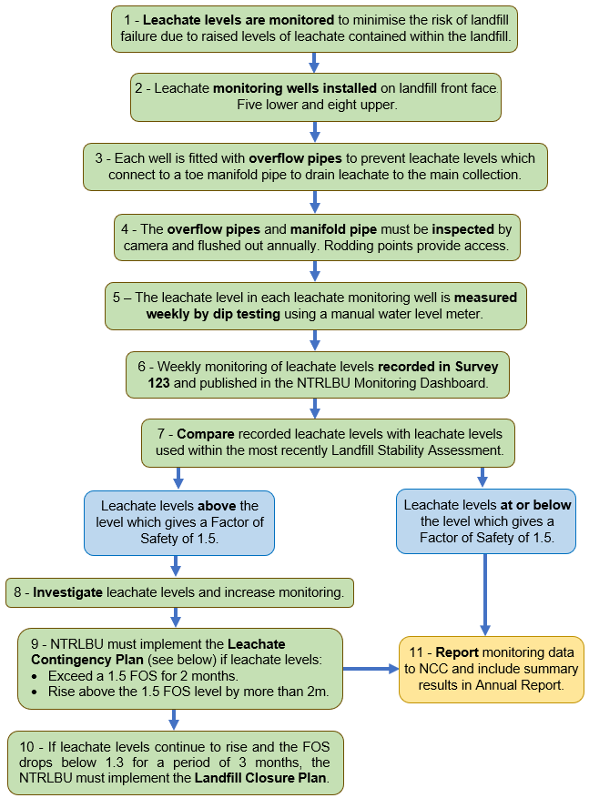
The objective of the landfill design parameters is to minimise the risk of landfill failure due to raised levels of leachate contained within the landfill.
The leachate levels in the landfill are monitored on a regular basis. The information is used to assess the stability of the landfill.
-
The buttressing of the front face of the landfill involves the installation of five lower and eight upper Leachate Monitoring Wells (MW A, MW B, MW C, MW D, MW E, PZ 1, PZ 2, PZ 3, PZ 4, PZ 5, PZ 6, PZ 7).
-
Each Leachate Monitoring Well is fitted with an overflow pipe to prevent leachate levels from rising above a particular height in the well.
The overflow pipes connect to a toe manifold pipe to drain leachate to the main collection system.
-
Rodding points are provided to the overflow pipes and manifold pipe to enable them to be inspected by camera and flushed out, which shall be done annually.
-
-
RM975261-D(19)
See picture of Monitoring Dashboard below.
-
RM975261-D(21)
The current Landfill Stability Assessment was undertaken by Tonkin & Taylor in 2019. The previous assessment was undertaken in 2012.
[GS - The 2019 assessment is still listed as draft in the LMP 2023.]
The 2019 Assessment provides stability review of York Valley Landfill in accordance with resource consent conditions controlling operation of the landfill facility.
The Assessment sets out Factors of Safety (FOS) for a deep failure of the landfill based on leachate levels within the landfill. The trigger levels for this stability assessment are set out in Resource Consent RM975261-D Schedule 3.
-
Rodding points are provided to the overflow pipes and manifold pipe to enable them to be inspected by camera and flushed out, which shall be done annually.
[MS - This is not being done, needs reviewing.]
RM975261-D(21)(i).
-
NTRLBU must implement the Leachate Contingency Plan if leachate levels:
Exceed a 1.5 FOS for 2 months.
Rise above the 1.5 FOS level by more than 2m.
The Leachate Contingency Plan sets out the NTRLBU’s process to reduce leachate levels within the landfill in order to maintain a factor of safety of at least 1.5.
The Leachate Contingency Plan includes contingency measures such as:
Improved leachate drainage;
Increased setback from the front face;
Buttressing of the front face of the landfill;
Benching and flattening of the front face
The Leachate Contingency Plan also includes a closure plan for the landfill, to allow proper doming capping and surface drainage, with a timeline for implementing closure, should early closure of the site become necessary.
RM975261-D(21)(ii). [RM975261V2]
-
The closure plan for the landfill sets out the process for the proper doming capping and surface drainage, with a timeline for implementing closure, should early closure of the site become necessary.
RM975261-D(21)(iii). [RM975261V2]
-
The NTRLBU mut provide a report for the preceding twelve months, reflecting the financial year, to the Divisional Manger of Planning and Consents, Nelson City Council at annual intervals, or on request.
The report must include the results of all leachate level monitoring undertaken, and interpretation of the results, and an assessment of the impact of the landfill on the environment.
RM975261 Sch 1(18). [RM975261V2]
NTRLBU Leachate Monitoring Dashboard

Leachate Trigger Levels - RM975261-D Schedule 3

Reference
-
The Consent Holder shall install and maintain the proposed remedial leachate collection system in accordance with York Valley Landfill Leachate Drainage Platform System, Earthtech Consulting Ltd, revised Plan No. 20 0053 dated Jan 2001.
-
The Consent Holder shall not place refuse within 10m of the front face of the landfill at RL 145. The maximum height of the fill shall rise from RL145 at a setback of 10m from the front face to a maximum height of RL160, at a setback 40m from the front face of the landfill. The landfill contours between 10m and 40m from the front face of the landfill shall be formed to provide the ability for the landfill to shed stormwater and for the fill face to be maintained in a stable condition in accordance with a geotechnical advisor’s requirements.
-
The Consent Holder shall monitor leachate levels in piezometers 1 and 2 and any additional piezometers required under Condition (24) of this consent. Monitoring shall be conducted on a weekly basis and the results compared with the leachate levels used within the most recently accepted failure surface and stability review, required under Condition 25.
-
The Consent Holder shall, within three months of the granting of this consent, prepare a contingency plan to be approved in writing by the Council's Compliance Officer, to reduce leachate levels within the landfill in order to maintain a factor of safety of at least 1.5. Contingency measures may include, in the first instance:
Improved leachate drainage;
Increased setback from the front face;
Buttressing of the front face of the landfill;
Benching and flattening of the front face
The contingency plan shall also include a closure plan for the landfill, to allow proper doming capping and surface drainage, with a timeline for implementing closure, should early closure of the site become necessary.
-
Should the FOS reduce below 1.5 then the following shall occur:
(i) The Consent Holder shall increase the frequency of leachate level monitoring in piezometers to weekly;
(ii) If leachate levels remain above the levels in Schedule 3 which provide a FOS of 1.5 over a period of two months, or rise by an amount greater than two metres above the levels in Schedule 3 which provide a FOS of 1.5, whichever occurs first, the Consent Holder shall implement measures in the contingency plan;
(iii) If leachate levels continue to rise such that the FOS drops below 1.3, based on leachate levels in Schedule 3, for a period of three months, the Consent Holder shall implement the closure plan.
-
For the purposes of this consent the term factor of safety shall mean: “The ratio of resisting forces to applied forces for a given static loading condition”
-
Prior to the acceptance of the failure surface and stability assessment required by Condition D(25) the following geotechnical parameters shall be used for refuse:
Density = 9.6 Kn/m3
c' = 5 kPa
Ø' = 21°
-
Additional piezometers shall be installed by 31 December 1999 in the following positions:
(i) Valley center line at chainage 55 m (approximately)
(ii) Valley center line at chainage 125 m (approximately)
(iii) Between 20 and 30 m west of the center line at chainage 125 m
(Chainage positions refer to Montgomery Watson drawings 68329.00, sheets 1 and 2.)
These piezometers shall be installed to record leachate head levels at or near the interface of the refuse with the in-situ subgrade soils.
-
The failure surface and stability assessment shall be reviewed for acceptance in writing by the Council's Monitoring Officer prior to filling above the levels approved by Condition D (18). The stability assessment and geotechnical parameters shall be subsequently reviewed for acceptance in writing by the Council's Monitoring Officer following every 10m increase in height of the landfill.
-
The Consent Holder shall revise Schedule 3 based on the results of any stability assessment undertaken in accordance with Condition (25) of this consent for acceptance in writing by the Council's Compliance Officer.
-
The geotechnical parameters used in Table 2.2 – Summary of Geotechnical Properties – Landfill Components of the Tonkin & Taylor report titled York Valley Landfill Static & Seismic Stability, dated November 2004, Job No 82777.011 shall be independently peer reviewed by a suitably qualified person who shall be approved by the Council's Compliance Officer. This peer review shall be submitted prior to 1 November 2005, to the Council's Compliance Officer. No reliance shall be placed on the geotechnical parameters contained in this report when assessing landfill stability and compliance with the conditions of this consent until the independent peer review has been completed to the satisfaction of the Divisional Council's Compliance Officer.
-
Where any piezometer, listed within any revised and accepted Schedule 3, becomes non-operational due to damage it shall be repaired, replaced or decommissioned as approved by a chartered professional engineer specialising in geotechnical engineering or an experienced engineering geologist and recognised as such by Nelson City Council, within six months of it becoming non-operational. Prior to any piezometer being replaced or decommissioned the Consent Holder shall supply a report, for acceptance, to the Council's Monitoring Officer from the chartered professional engineer or experienced engineering geologist confirming that the factor of safety of the landfill can still be calculated with the same, or improved, level of confidence.
-
See Leachate Trigger Levels Table above.
Other Discharge Procedures
-
11/24 - Page uploaded from Word document Leachate - Draft 3.
-
Require link for York Valley Landfill Leachate Drainage Platform System, Earthtech Consulting Ltd, revised Plan No. 20 0053 dated Jan 2001.
-
Please send updates, changes and comments to landfill@ncc.govt.nz